Monitoring
Water temperature is the most important water quality variable in terms of understanding stream reach suitability for salmonids (www.krisweb.com/stream/temperature.htm). ERRP has been conducting a Tenmile Creek basinwide water temperature study since 2018, with funding assistance from the State Water Resources Control Board since 2021. The SWRCB 319h grant also covers air temperature monitoring and sediment in pools at key locations. A description of the study design for data collection and complete description of methods is included in the Quality Assurance Project Plan: Water Quality Sampling and Analysis paper developed for the SWRCB.
Water Temperature Monitoring
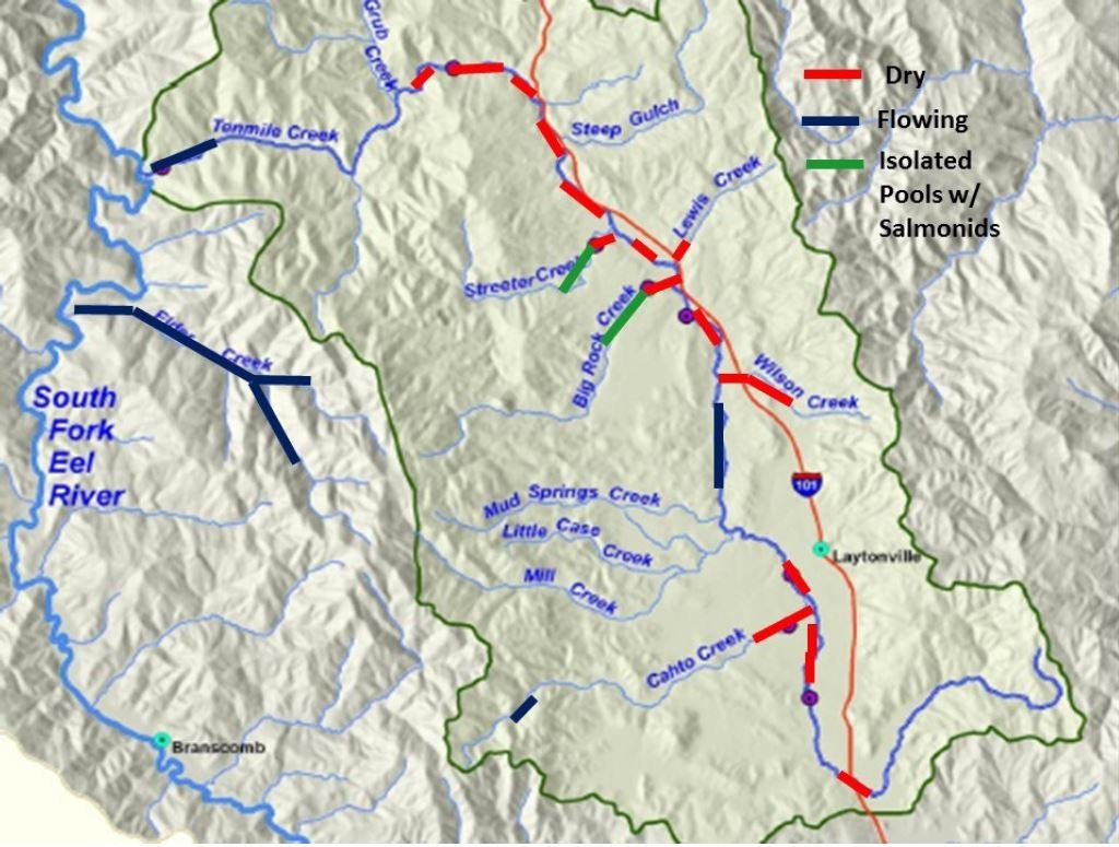
Tenmile Creek historically was suitable habitat for Chinook salmon, coho salmon and steelhead trout throughout the year, but now many reaches and tributaries become too warm to be supportive and in some years lose surface flow all together. Since 2021, the SWRCB 319h grant has funded deployment of automated temperature probes that are tied to a weight and placed in flowing water to measure the streams ambient temperature. Temperatures have varied widely depending on the flow year, and probes are exposed to the air when streams go dry. For a full report on water temperatures and flow conditions, see reports developed for this project: Tenmile Creek Aquatic and Riparian Condition Reports for WY 2022 and WY 2023. Below are maps showing stream reach conditions in Water Years 2018 - 2023. ERRP collected data for a previous State Coastal Conservancy grant since 2018 and data and analysis are available in previous reports for WY 2018-2019 and WY 2020-2021.
Riparian Air Temperature Monitoring
The riparian zone of a stream extends back from the water’s edge for different distances, depending on the slope of the adjacent hillside. There are many water loving tree species that live in these areas including alder, willow, maple, cottonwood, and ash trees, but riparian zones can also be comprised of conifers and oaks. Benefits of a healthy riparian zone are shade, cover over the stream, moderated stream temperatures, reduced bank erosion, accretion of sediment, and production of insects for fish food. To learn more about riparian zones, see http://www.krisweb.com/stream/riparian.htm
Location of air temperature probes on Cahto Creek.
In addition to the bioengineering project that will produce willow thickets that extend out over the stream, non-native Himalaya berry will be removed from Cahto Creek sites on the opposite bank and native tree gallery forests will be created in their place (see Hogan and Mueller plans). Riparian zones can have substantial influence on water temperatures and ERRP is conducting a study on Cahto Creek at ten nine different sites to determine air temperature variability related to stand conditions. For a complete summary of data and analysis of air temperature data, see the Tenmile Creek Aquatic and Riparian Condition Report for WY 2023.
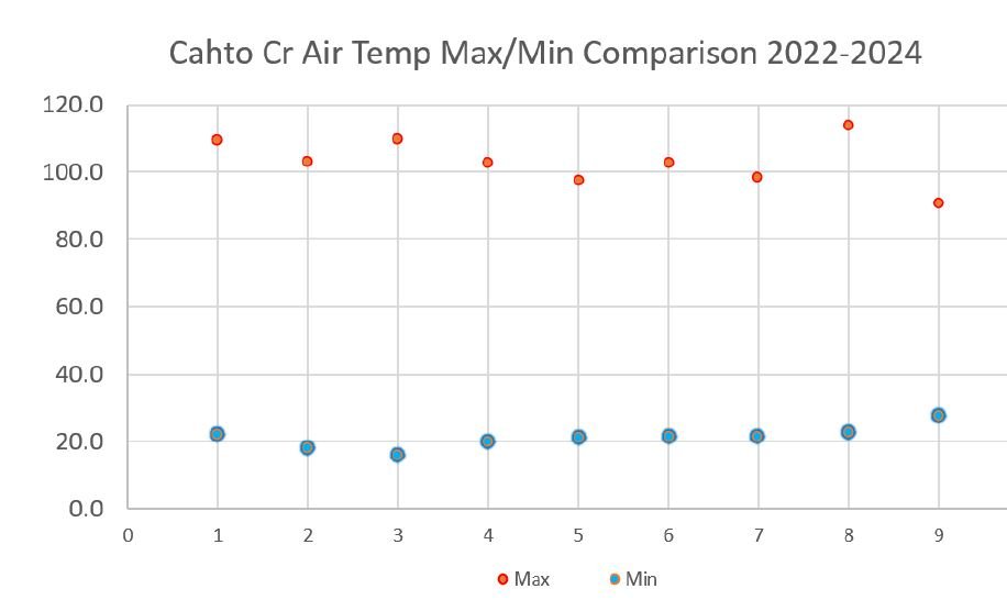
Open sites, such as the Hogan property on Cahto Creek, where there is currently only Himalaya berry, and along the power line at the Cahto Creek Ranch, had the highest and lowest air temperatures. Sites with multi-tiered canopies had lower peak temperatures and less severe cold in winter as they create a microclimate that can also buffer water temperatures. The baseline data collected at the Hogan site will allow long term assessment of changes with seral stages.
Location key for air temperature probes with maximum temperature in Fahrenheit.
Maximum and minimum air temperatures from September 2022 to March 2024
Sediment in Pools
Steve Brown taking measurements for V-Star survey of Streeter Creek.
Effects of excess sediment in streams may be subtle, where fines fill spaces between gravel on the bed, or they may be dramatic where pools are filled. A method know as V-Star can be used to measuring fine sediment in pools in order to quantify sediment levels. Excess sediment transport reduces aquatic insect production, decreases salmon and steelhead egg and alevin survival, fills pools and can widen the stream course making it more subject to warming. In the most extreme cases, streams can be so deeply buried that they may lose surface flow. Learn more at: www.krisweb.com/stream/sediment.htmi
The SWRCB 319h grant funded sediment monitoring to explore whether reduction in sediment from bank stabilization by bioengineering projects could be measured nearby, as well as to gauge the level of sediment in Tenmile Creek tributaries. V-Star was devised by the U.S. Forest Service for sediment trend monitoring and it uses a probe to measure the depth of sediment, and a ratio of the amount of fine sediment to the total volume of sediment and water. The North Coast Regional Water Quality Control Board has set a V* value of 0.21 as a target value, based on regional studies (Knopp 1992). Data collected in 2022 and 2023 show that most locations within the Tenmile Creek basin have scores of less than 0.21, except for Cahto Creek, which had a value of 0.24 in 2023.
Peterson Creek and Mill Creek have extremely low fine sediment levels, similar to control stream Elder Creek (0.07), which indicates good conditions for aquatic insect production and salmon and steelhead spawning. While insight has been gained through the 2022 and 2023 V-Star monitoring effort, it is not a good tool for locally monitoring improvements in pool sediment conditions after project construction as intended. Despite tons of sediment being contributed to Cahto, Mill and Streeter creeks as a result of bank erosion at sites to be treated, it was transported downstream and no changes in V-Star in adjacent reaches were measured. Consequently, V-Star monitoring is being discontinued. Although upper Tenmile Creek was not sampled, reconnaissance at Harwood Park showed deposits of fine sediment greater than three feet deep indicating that there are major sources of sediment somewhere upstream. Big Rock Creek had a major influx of sediment in 2022, but ERRP lost access and could not collect additional data to further document conditions.
Tenmile Creek adult male Chinook salmon moving upstream above Peterson Creek.


